After a long time of absence writing here I have returned to say that the ideas for using marginal space never leave me. One idea I have is to petition the City of Pueblo about certain marginal spaces that I study in a catch as catch can time frame. I do not direct a foundation with maintenance funds, and so I would seem to come hat in hand to the community to see what the attitude is towards grounds maintenance, or allowance for additional consideration of new objects set into their routines. I take pictures, I envision perspective being reset or dramatized.
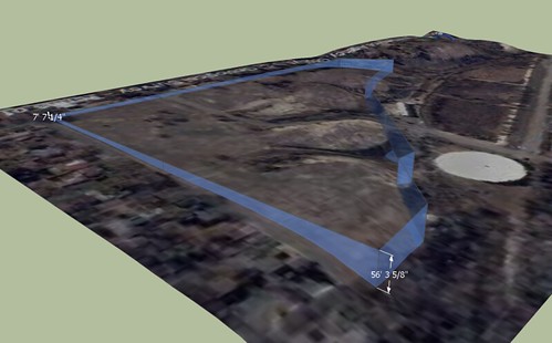
One site I wonder about is the grassy areas between the street and the sidewalk surrounding the block where the old St. Mary's Hospital once stood. To be honest I do not know if the grounds are maintained by property owner or the city. It is bounded southwest by Grant Ave., northeast by Pitkin, southeast by Quincy, and northwest by Jackson.
Marginal Space
This blog investigates the possible site placement of public sculpture on marginal land in and around the urban areas of Pueblo, Colorado. In this, the author proposes bringing new or different focal points into places that may have been previously under-valued, under-utilized or even undiscovered for reflective purposes. It will also chronicle the development of a non-profit art foundation which will generate the funding for this endeavor.
Sunday, July 9, 2017
Sunday, April 3, 2011
Study One
The first subject site mentioned was included in the preceding blog, Virtual Sculpture, that the author developed to display Sculpture ideas. The one referred to is Visualization Of A Site. dated December 11, 2009
Google Sketch-up (version 8) has now updated with the capability to base a sketch on top of Google Earth mapping.
It is an interesting tool that definitely helps visualize land use, especially as regards marginal use. The above photo approximately illustrates a transparent cordon around a 40 acre parcel that has been left vacant for many years.
Saturday, April 2, 2011
First Post
My first post will merely serve to announce my stated purpose. Many years of working in Pueblo, Colorado have left indelible ideas about where certain places could be developed into reflective sites.
Subscribe to:
Posts (Atom)